Welcome!
This project is a cooperative project sponsored by the US Geological Survey (USGS) that will result in the collection and processing of high resolution 2 meter nominal pulse spacing or better LiDAR and meet objectives of the American Recovery and Reinvestment Act (ARRA). The DEM data generated from the LiDAR will be added to The National Map, a set of national geospatial datasets available to the public at no cost. The raw point cloud LiDAR will also become available through the CLICK (Center for LiDAR Information Coordination and Knowledge). More information on these datasets may be found at http://nationalmap.gov and http://LiDAR.cr.usgs.gov.
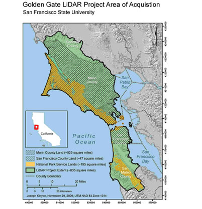
Specifically, The Golden Gate LiDAR Project is a project of San Francisco State University (SFSU) to acquire LiDAR data for the counties and parks of the Marin and San Francisco Peninsulas. The Principal Investigator is Dr. Ellen Hines of SFSU who has extensive GIS project management experience and is supported by organizations with experience managing projects and budgets of similar or greater size and scope of work. The area of interest for airborne LiDAR data acquisition includes 835 square miles of project area and will focus on the land area of Marin County, San Francisco County, Point Reyes National Seashore and the Golden Gate National Recreation Area (Figure 1). The project will complement and overlap coastal LiDAR acquisition planned for the same area that includes near shore bathymetric data. The entire project area is within high priority LiDAR acquisition areas identified by the USGS to support the creation of high resolution elevation data for National Map. These areas are additionally prioritized by the hazards, sensitive ecosystems and adjacency of dense urban populations to the coast and to park lands.
The Golden Gate LiDAR project is based upon the watershed boundaries for all watersheds that contain the lands of Marin County and San Francisco County. It also includes the watersheds that contain Point Reyes National Seashore and the Golden Gate National Recreation Area. The area of interest therefore includes watersheds that are also located in southern Sonoma County and northern San Mateo County and when combined total ~835 square miles (planimetric estimate) of area. (Please refer to the map titled Golden Gate LiDAR Project Area of Acquisition for a visualization of this location and extent.) The project area includes the Marin Peninsula and San Francisco Peninsula that form the western edge of San Francisco Bay and San Pablo Bay. These peninsulas are north and south of the strait at the mouth of San Francisco Bay called the Golden Gate. This region is the northern part of the Central California coast.
The primary intent of this specification is to create consistency across all NGP funded LiDAR collections, in particular those undertaken in support of the National Elevation Dataset (NED). Unlike most other LiDAR specs which focus on the derived bare-earth DEM product, this specification places unprecedented emphasis on the handling of the source LiDAR point cloud data. This is to assure that the source data collected remains intact and viable to support the wide variety of non-DEM science and mapping applications that can benefit from LiDAR technology. In the absence of other comprehensive specifications or standards, it is hoped that this specification will, to the highest degree practical, be adopted by other USGS programs and disciplines, and by other Federal agencies.